Practical information
- Correct destination
- Roman Bridge, municipality of Alcántara. Plan travel from Valencia de Alcántara separately.Source: Alcántara town council: Roman bridge
- Monument access
- The information consulted does not publish a bridge admission fee. Confirm passage and access restrictions with Alcántara tourism staff.Source: Alcántara town council: Roman bridge
- Published trail
- PR-CC 131: 2.55 km circular, estimated 1 hour and 130 m of ascent. Municipal trail figures, consulted on 1 October 2026.Source: Alcántara town council: Bajo el Puente trail
Bridge arches, central arch and temple
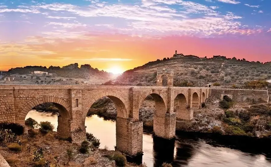
Look at the relationship between the six arches, piers and the Tagus channel, then seek out the central honorific arch and the small temple associated with the bridge. A wide view explains the engineering better than a photograph taken only from the roadway. Use permitted stopping places and remain aware of traffic nearby.
A work from Trajan's reign
Construction dates to the early second century under Emperor Trajan and is associated with the architect Cayo Julio Lacer. The bridge helps explain links between territories and adaptation to the river. Sources give differing precise measurements and dates; for planning a visit, placing the work in its Roman context is more useful.
A trip to a different municipality
Check your road itinerary with Alcántara as the destination. Before leaving, decide between a monument stop and a longer day including the town. Do not automatically add a trail to a tight schedule: driving, eating and viewing the bridge take time on top of walking, and this guide gives no unverified driving estimate.
The Bajo el Puente trail
The town council's sheet describes PR-CC 131 Bajo el Puente as a circular trail of 2.55 km, with an estimated hour and 130 m of ascent. These figures describe that trail, not a visit to the monument. Check the route and current conditions before following it; elevation matters even when the distance looks short.
Separate viewpoints from your walking route
Save the trail map and bring water if you choose to walk it. For a short visit, choose a safe place to appreciate the whole bridge and avoid making an improvised roadside stop for a photograph. Complete the trip with a walk through Alcántara and check separately the opening of any building you want to enter.
Add to your trip
Castle-Fortress
Discover the fortress and the Early Settlers Interpretation Centre.
Dolmens of Valencia de Alcántara
Choose a megalithic walk and discover El Mellizo among woodland pastures and rural paths.
Marvão
Castle, walls and viewpoints for a day out in the Serra de São Mamede.
Frequently asked questions
Is the bridge in Valencia de Alcántara?
No. It is in Alcántara, a different municipality in Cáceres. Enter the bridge's full name on your map to plan the excursion.
Does the stated hour cover the whole excursion?
No. It is the official estimate for the Bajo el Puente trail. It excludes driving, stops at the monument and visiting the town.
Sources and review
Opening arrangements can change. Confirm interior visits and access conditions with the responsible organisation before travelling.
- Alcántara town council: Roman bridgeConsulted: 1 October 2026
- Alcántara town council: Bajo el Puente trailConsulted: 1 October 2026